| Home |
| Download |
| Buy |
| How to use |
| FAQ |
| Contact us |
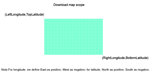
What projection does Google Maps use? How to download? Firstly, select a maps type in left tree, then input a task name, such like "Mytask.gmid". All task files are saved as *.gmid. If you want to continue an old task, click button "Open task...".
Parameters explainment:
For longitude and latitude, the input measurement is degree. You can convert the measurement of "Degrees, Minutes,Seconds" to "Degrees" by click menu How to get the lat/long information from Google Maps? click here to see more examples How to run it from command line? If your install folder is "C:\allmapsoft\gsmd", you can use the followed command to lauch it automatically: C:\allmapsoft\gsmd\downloader.exe para1 para2 para3 para4 para5 para6 para7 para8 para9 para1: task name(only filename, without path) For example: If you want to download an area, Google Satellite Maps (Maps type ID=1, see the followed table): task name=test.gmid;maps type=1;zoom-level=12; left-longitude=2; right-longitude=3; top-latitude=49; bottom-latitude=48; path to save=C:\downloads Then the command line should be: "C:\allmapsoft\gsmd\downloader.exe" "test.gmid" 1 12 2 3 49 48 "C:\downloads" if you want to hide the window, please use: "C:\allmapsoft\gsmd\downloader.exe" "test.gmid" 1 12 2 3 49 48 "C:\downloads" hide
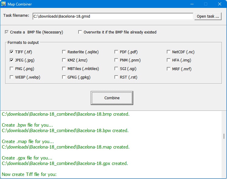
After downloading, you can also run combiner.exe from command line mode: "C:\allmapsoft\gsmd\combiner.exe" para1 para2 para3 para1: task name(full path) For example: "C:\allmapsoft\gsmd\combiner.exe" "C:\downloads\test.gmid" jpg,tif,mbtiles,gpkg When task finished, the downloader or combiner will be automatically closed.
1. Google map uses a protection mechanism to keep a good quality of service. If one makes too much requests, google map will add its IP address to a blacklist, and you may see a message: If this happened, Google Satellite Maps Downloader will show a messge in log window: May be your IP is banned by Google. Then you must wait for some time(24 hours) or change to another IP. To avoid IP banned, you can try to set the downloader to pause some minutes.
2. For some areas, there are no high precision images on google's server, so may be caused a error "404 not found" when you try to download such images. If this happened, you need to set smaller zoom size to download. (For most areas, the max zoom level is 18) 3. Sometimes when you click 'download' button it shows this message: "Cannot create file c:\allmapsoft\gsmd\ini\v.txt", you can "Run as administrator" to solve this problem. How to view downloaded satellite images? You can view downloaded maps without combining them into one big file. Then open a project from menu "File"->"Open task..." to view the map.
View map with browser:
click here to see more examples
How to combine small images into one big image?
We provide a tool, you can run it from menu "Tools"->"Map Combiner".
How to download other type maps? Google Satellite Maps Downloader can only download satellite images of Google Maps, if you want to download other types of maps, we provide other tools: Google Maps Downloader : It can download normal maps, satellite maps, terrain maps and hybrid maps of Google Maps. Universal Maps Downloader: It can download maps from many maps servers. Please click here to see all map types (2800+) , and click here to see all tiles samples. Offline Map Maker: Difference from Universal Maps Downloader: Offline Map Maker can download multi zoom level in one task, but Universal Maps Downloader can only download single zoom level in one task. google earth images downloader: It can download images (including historical imagery) from google earth servers, not google maps.
How to use offline maps in RMaps, Locus Map or OruxMaps? After exporting all downloaded tiles into a sqlite database, then you can use the sqlite file in some Android apps, such like RMaps and OruxMaps.
For RMaps: When you finished exporting tiles to sqlite database with export type 'For RMaps or Locus Map', you will get a file: your_task_name.gmid.sqlitedb, then copy it to your Android device, to your RMaps installed path, might be like '/sdcard/rmaps/maps/', then refresh your RMaps offline maps, you will see a new offline maps "your_task_name_gmid.sqlitedb". For Locus Map: Same as RMaps, when you finished exporting tiles to sqlite database with export type 'For RMaps or Locus Map', you will get a file: your_task_name.gmid.sqlitedb, then copy it to your Android device, to your Locus Maps installed path, might be like '/sdcard/Locus/maps/', then refresh your Locus offline maps, you will see a new offline maps "your_task_name.gmid.sqlitedb". For OruxMaps: When you finished exporting tiles to sqlite database with export type 'For Oruxmaps', you will get two files: your_task_name.gmid.otrk2, your_task_name.gmid.OruxMapsImages.db, you need to rename the your_task_name.gmid.OruxMapsImages.db to OruxMapsImages.db, then on your Android device, in your OruxMaps installed path, might be like '/sdcard/oruxmaps/mapfiles/', create a new folder suchlike 'exmaple', then copy "OruxMapsImages.db" and "your_task_name.gmid.otrk2.xml" to this folder, refresh your oruxmaps offline maps, you will see a new offline maps "your_task_name_gmidmap".
What projection does Google Maps use? Google Maps uses Web Mercator ( EPSG:3857), more detail information about it, you can goto these links to see: http://wiki.openstreetmap.org/wiki/EPSG:3857
|